Friday, December 12, 2008

NJ's Somerset County Flood Information System and NWS' Middle Atlantic River Forecast Center: In Action to Notify and Project Local Flooding

I knew it had been raining since yesterday, but was the bridge (that I normally drove across to work) closed?

I opened my e-mail, and found a message, sent by Somerset County, New Jersey early this morning at 5:03 AM, notifying me that the bridge had been closed. Per suggestion of Mr. Carl Andreassen, the Principal Hydraulic Engineer for the County, I signed up for this
e-mail notification service about a month ago, and this is the first flood-related notification that I received.

Whenever the river level/stage rises up to seven (7) feet, the action stage, the police will be dispatched by the emergency services to close the bridge. The flood stage at this location is nine (9) ft. That is, the bridge will not actually be flooded until the water level reaches 9 ft. There is a stream gauge located close to the bridge; its measured water level is transmitted to the Somerset County Flood Information System via a satellite transmitter as well as a phone line, as a direct connection. The stream gauge is operated by the U.S. Geological Survey. See the picture for the actually measured water level, as indicated by the blue line.

The National Weather Service (NWS)'s Middle Atlantic River Forecast Center, via NWS' Advanced Hydrologic Prediction Service (AHPS), go further to project what the water level might actually approach. See the picture for the predicted water level, as indicate by the dotted green line.

According to the NWS' AHPS prediction, the bridge would remain closed through the evening during my commute home. Of course, I can check the actually measured water level right before I leave my office. I can also assume the bridge would remain closed until a further e-mail notice, a bridge re-opening notice, from Somerset County.

It is nice to live in the information age!

Credit: The image above was made from the NWS's MARFC website.

My presentation contains additional info on flood forecast and warning as well as other aspects of urban flood management.

Sunday, November 30, 2008

Water Main Bursts in Franklin Township, New Jersey

In the late morning of November 18, 2008, a 60-inch water main broke in Franklin Township, Somerset County, New Jersey. The burst had a ripple effect on 100,000 customers in Somerset, Middlesex and Union counties, prompting officials to close schools and residents to boil water. (Both my home and office were affected.)

Complaints ranged from low water pressure to no water at all in 18 towns, said Richard Barnes, a spokesman for New Jersey American Water. As a precaution, the utility issued a boil water advisory.

The rushing water eroded the earth underneath the road, washing away part of Weston canal Road. Water gushed into the Delaware and Raritan Canal. (See the picture.)

The main is a major pipeline for transmission of water, and was first installed in 1958.

Although the cause of the break is still under investigation, this incident again highlights the urgent need for condition monitoring and rehabilitation of the nation's water infrastructure.

(Info Source: The Star-Ledger. Photo Credit: Ed Pagliarini, MyCentralJersey.Com)

Monday, September 1, 2008

Hurricane Gustav on News Orleans: A Narrow Miss

Gustav has made the landfall near Cocodrie, Louisiana, 72 miles southwest of New Orleans, as a category 2 hurricane. New Orleans has avoided a direct hit, what a relief!

Map to the left shows the levee system to protect New Orleans. The levee system was breached at numerous locations during Hurricane Katrina (category 3) three years ago. The levee system has since been repaired to or beyond the pre-Katrina protection level. However, the levee system planned by the US Army Corps of Engineers to protect the city from a "100-year storm" is still being re-built or newly constructed and will not be completed by 2011.

It should be pointed out that the strength (height and speed) of a surge at a specific location depends on the approaching angle of the hurricane as well as the type and length of the channel that the initial surge would have to travel through, not just the category number. Highly sophisticated computer models are available and can be used to forecast the flood level more accurately.

I applaud the coordinated efforts by Federal, State, and local authorities to successfully inform and evacuate residents in advance. Forecasting the flood level is not yet an exact science, but it is better to be safe than sorry.

For Gustav, the surge water has now entered the city canals, and some water is splashing over the top of the Industrial Canal (the Inner Harbor Navigation Canal on the map). May the levee system in New Orleans continue to hold and the water drainage/pumping system continue to function to minimize the property damages!

(Source of Map: 2006 Report by the US Army Corps of Engineers)

Wednesday, August 13, 2008

The Stellwagen Bank National Marine Sanctuary

My family and I visited Cape Cod and Boston last weekend. Photo to the left shows a family of four whales (two parents above water and two babies under water) hanging around our tour boat. Awesome!!!

My album contains additonal photos of the whale watching.

Tuesday, July 15, 2008

Fish Ladder at Lake Lenape Dam, Mays Landing, New Jersey

I visited Lake Lenape Dam yesterday. It is about 20 miles west of Atlantic City.

The photo to the left shows a fish ladder that was constructed at the dam in 2006. The fish ladder provides passage for migratory fish with access to 15 miles of upstream spawning and foraging habitat. The dam is co-owned by Atlantic County and Hamilton Township.

Entrance is adjacent to the spillway discharge (on right side of the photo) at invert elevation of 1 foot below the mean sea level. The ladder exits into the lake (on left side of the photo next to the non-operating powerhouse) at invert elevation of 8.3 feet above the mean sea level. The fish ladder is 200 feet long.

A beautiful lake, a beautiful water fall (spillway discharge), a renewable source of energy, plus happy fish! What more we could ask for from a good old dam?

My album contains additional photos of the dam.

Sunday, June 22, 2008

Iowa City Flood 2008

Photo to the left shows the flooded Iowa River at the renowned University of Iowa hydraulics lab on June 14.

I visited the lab twice in the past. Folks there actually used a real fish to test how it would move up the fish ladder. The fish ladder is installed at many dams, and is a life passage for migratory fish such as salmon.

(Photo Credit: James Hemsley)

Tuesday, June 10, 2008

Update 6 (Final Update): A Great Success in "Quake Lake" Draining! Congratulations to Chinese Engineers! (唐家山堰塞湖排水获巨大成功! 热烈祝贺中国工程师们!)

A deep channel has cut through the landslide dam by the "natural" current. See photo to the left for the initially cut through channel around 9:00 a.m., June 10, Beijing time, with lake water surface elevation of about 742 m and discharge rate of about 1,200 cubic meters per second. Channel inlet bottom elevation was cut down from 740 m to about 720 m (about 20 meters lower) and channel was cut wider from about 10 m to about 150 m. The lake water level was brought down from its highest at 742.96 m (8:00 p.m., June 9, Beijing time) to the present reading of 719.48 m (8:00 p.m., June 10, Beijing time). As a result, over 100 million cubic meters of the lake water was drained out of the lake. The population at risk of future downstream flooding has been reduced from 1.3 million (upon catastrophic collapse of the landslide dam) to 50,000.

Although the peak discharge rate was very high at 6,420 cubic meters per second during the course of channel cutting and lake water draining (and was rapidly increased to this peak value from 500 cub. m/s within three and half hours, from 7.56 a.m. to 11:30 a.m. on June 10), the downstream area flooded by this release of water was far less than the planned 1/3 dam collapse inundation zone. Note over 200,000 people were already evacuated about 10 days ago, in preparation for the possible 1/3 dam collapse scenario. Therefore, I would define this initial draining of the "quake lake" water as a great success! The engineers' original drainage scheme including the sluice channel design worked.

Congratulations to the Chinese engineers for their great success!

P.S.: I am also glad that my projection of the unnecessary second, deeper drainage channel to "force" an additional outflow was correct (see my Update 5 posted on June 8). Construction of the second channel was stopped at 6:00 p.m., June 9 as the lake outflow through the first already-constructed channel increased to 81 cubic meters per second (cms) and was approaching the lake inflow rate of 115 cms.

Photo credit and info source: Xinhuanet

Sunday, June 8, 2008

Update 5: Lake Started to Drain through Sluice Channel "Naturally" and Second being Dug to "Force" Additional Draining ("自然"道流开始了,正在开挖第二条导流槽强行增大排水量)

At midnight of June 6 (Beijing time), the lake water level rose to 740 m, the highest bottom elevation of the constructed drainage/sluice channel. The outflow was anticipated to start at that moment. However, a 0.4 m high dirt block was later constructed in the channel in order for soldiers to make the channel wider, deeper, and steeper (no specific channel dimensions were given). The soldiers were dispatched back to the dam to modify the channel in the afternoon of June 6.

At 7:08 a.m., June 7 (Beijing time), the "natural" outflow started. The reported flow rates were 2 cubic meters per second at 2:15 p.m. (with current velocity of 1.5 m/s) and 10 m3/s at 6:00 p.m. (at 741.02 m lake level). On June 8, the reported flow rates were 20 m3/s at noon (at 741.82 m) and 25 m3/s at 7:15 p.m. These inflow rates were much smaller than the reported rate of inflow to the lake, more than 100 m3/s.

The landslide dam was stable, but was not getting removed. The drainage channel was not scouring significantly and not getting much wider and deeper due to the relatively small outflow rate. The outflow rate is relatively small thus far since it would take some time to build up the lake water level/head above the channel bottom to push the water through. The slow water level rise is a result of the relatively small upstream inflow rate (due to the relatively small rainfall in the upstream watershed). The outflow rate was also reduced by partial blockage of the channel by debris floating down from the lake.

While clearing out or breaking down floating debris on the lake surface, we could simply wait for the lake water to rise several more meters so that all the inflow (more than 100 m3/s) would be pushed through the channel. We could also wait for the next rain storm that would lead to a higher outflow rate. The high outflow rate (more than 100 m3/s) would scour the existing channel deeper and wider and would eventually form a relatively stable channel through the landslide dam. If we are lucky enough, there might not be much of the landslide dam left afterward. This was exactly what Chinese engineers originally planned for, I assume.

However, understandably, Chinese leaders, engineers, and especially over 200,000 residents who have been relocated to the high ground since about ten days ago (plus other over one million residents on high alert for emergency evacuation) are running out of patience.

To increase the outflow rate, it was decided yesterday to dig another, deeper channel several meters away from the existing channel. These two channels are anticipated to merge together once the dirt barrier between the two channel is washed away during a high flow.

At the end of the second channel digging, the soil/debris pile at the inlet would have to be removed by a remotely-controlled explosion. Since the inlet bottom elevation would be below the lake water level at that time, once the inlet is blast open, water will gush out from the "quake lake", in addition to that being released out from the first channel.

My four concerns for digging the second channel, in comparison to waiting for a "natural" enlargement of the first channel:

1) Engineers and soldiers are working in a highly risky environment;

2) The explosion used to open the channel inlet, though of relatively small strength, might still trigger a catastrophic collapse of the landslide dam;

3) The sudden gush of water, immediately after the explosion, might create an impact or shear force too strong for the dam to stand, leading to a catastrophic collapse;

4) The wider channel (the existing plus the new) would lead to a lower lake level (a smaller head) in front of the channel and a smaller current velocity. The smaller current velocity may not be sufficiently large to continue scour the channel(s) and to eventually remove the dam.

My best wishes to the additional efforts to release water from the landslide dam at Tangjiashan, but maybe a better option is to leave where it is and let the first channel do the entire job, "naturally!"

Therefore, I would like to suggest a halt to construction of the second channel on the dam.

我建议停止开挖第二条导流渠。原因如下:

1。现有的导流渠正冲得越宽越深,泄流量正变得越来越大,也就是说,正在平稳走向全功能发挥作用。我估计再过一至两天,水位就会涨到一定高程(最多涨到 744 米),排水流量就可以达到每秒一百多立方米,泄水量就会大于进水量,湖水位就会开始降落而越来越底。 继续开挖第二条导流渠就没有必要了。

2。继续开挖第二条导流渠可能会带来溃坝的风险。进水口要炸开,爆炸本身有可能引起溃坝。炸开口后的突然大量来流也有可能引起坝趾过度冲刷而掏空,而溃坝。

3。两条渠道加起来可能会太宽,水头会太底,流速会太底,而无法达到既慢慢冲走堰塞体又不发生倾刻溃决的最理想目的。

4。工程师和战士们现在在堰塞体上操作有一定的生命危险。

Info source: Xinhuanet

Tuesday, June 3, 2008

Update 4: Possible Upstream Landslide to Trigger Dam Collapse (如上游滑坡会瞬间引起溃决) - Landslide Dam Removal at Tangjiashan "Quake Lake"

Within the upstream "quake lake" area, a massvie mountain slope is at risk of sliding down. If the upstream landslide does occur, a huge surge will be created in the lake, leading to an instant collapse of the existing landslide dam. This was warned by Mr. Liu Ning (family name given name), the Chief Engineer of China Ministry of Water Resources.

水利部总工程师、唐家山堰塞湖抗震抢险指挥部专家组组长刘宁说:“根据多次实地考察,唐家山堰塞湖淹没的漩坪镇下方,存在一个2000多万方的滑坡体,一旦发生滑动,会造成巨大的涌浪,瞬间引起溃决。”

Info source: Xinhuanet

Monday, June 2, 2008

Update 3: Significant Seepage Observed (大量水渗过堰塞体) - Landslide Dam Removal at Tangjiashan "Quake Lake"

Rate of water seepage suddenly increased from the bottom of the landslide dam at 14:50 on June 1 (Beijing time). Fortunately, up to 17:00 on June 2, the seepage flow rate was stabilized to approximately 10 cubic meters per second. I estimated this as about 10 percent of upstream inflow rate to the "quake lake." In my opinion, this seepage rate is still quite large. I hope this would not lead to a "piping" failure of the landslide dam before the start of the natural outflow from the completed drainage /sluice channel.

At 14:00 on June 2, the lake water level was at 735.78 m. Since not much rain is in the forecast for the coming days, the natural water discharge from the lake is now expected to occur on June 5.

“1日14时50分,唐家山堰塞湖坝底一处渗漏出现流量忽然加大的情况,但到2日17时为止,流量基本稳定在10个流量左右。” 我估算这相当于进湖水流量的十分之一。我认为这渗流量太大了。但愿不会(在自然导流之前)发生堰塞体内管涌而溃堤。

“截至2日14时,唐家山堰塞湖水位高程为735.78米,比24小时前上涨1.24米。因气象部门预测近日无明显降雨,水利专家测定唐家山堰塞湖泄洪时间可能推迟到6月5号左右。”

Info source: Xinhuanet

Saturday, May 31, 2008

Update 2: Final Constructed Drainage/Sluice Channel Dimensions (最后建成导流明渠尺寸) - Landslide Dam Removal at Tangjiashan "Quake Lake"

By 22:00 May 31 (Beijing time), the entire channel was finalized and completely constructed (see photo to the left for a view of the channel inlet segment). The final channel dimensions are: Total length = 475 m; bottom elevation of inlet segment = 740 m, bottom width > 7 m; bottom elvation of the middel segment = 740 m, bottom width > 7 m; bottom elevation of outlet segment = 739 m, bottom width > 10 m.

The channel was further changed to make the bottom wider in the downstream segment than the upstream segment and the bottom slope milder in the upstream segment than the downstream segment.

[Other reports: 1)"Leaving a 475-meter-long channel up to 10 meters wide on the giant blockage". 2)The total channel length as 475 m, inlet elevation down to 740 m, and outlet elevation down to 738 m. 3)Inlet channel bottom elevation of 739.15 m - at the inlet edge I assume. 4) Near 4 meters wide at the narrowest location from a CCTV reporter (Bai Songyan)'s body measurements]

“经过前方621名和后方400名武警官兵、水利专家连续6天昼夜奋战,截至31日22时,唐家山堰塞湖应急疏通工程建设任务正式完成。”

“唐家山堰塞湖抢险现场副总指挥、水利部总工程师刘宁介绍说,截至31日22时,共完成土石方开挖13.55万立方米,钢丝笼护坡4200立方米,疏通道路17公里,平整场地14040立方米,清障树木35000立方米。此次抢险共投入推土机26台,自卸车4台。”

“截至目前,开挖的泄流槽总长475米,进口段底高程740米,底宽大于7米。中间段高程740米,底宽大于7米。出口段高程739米,底宽大于10米。”

[其它报导: 1)475 米长 宽至 10 米。2)“泄洪槽总长475米,泄洪槽进口高程降至740米,出口高程降至738米。”3) 泄流槽(进口)高程739.15米 - 我想是在进口边缘。4)中央电视台记者白岩松用身体测量最窄处近四米宽。]

Info source: Xinhua; Photo credit: Reuters

Update 1: Channel Dimensions Changed - Two Meter Deeper and Bottom Slope Milder (明渠改深及底坡缓了)- Landslide Dam Removal at Tangjiashan "Quake Lake"

The channel inlet would be made two meters deeper, and the channel outlet one meter deeper. Over almost the same channel length, the bottom slope would be much milder at about half of what originally planned. The changed channel dimensions are: Length = 320 m, top width = 50 m, bottom width = 8 m. Depth at upstream end = 10 m, that is, the dam was excavated from the original top surface elevation of 750 m down to 740 m. Depth at downstream end = 13 m, that is, the dam was excavated from the original top surface elevation of 752 m down to 739 m. The channel is expected to be completed by noon (New York time) or midnight (Beijing time) today.

At 14:10 Beijing time, the lake water level was 734 m, still 6 m below the channel bottom. The water level rising speed was 1.5 m per day. The lake level is expected to rise up to the channel bottom in three or four days and the water would start to discharge downstream through the channel.

Change to the deeper channel was attributed to a desire for an earlier water release (because of the decreased channel bottom elevation). They were able to make this change because the construction was several days ahead of schedule. The original plan to blow open an entrance to the drainage channel using explosives was also scraped since it was no longer necessary. The change to a milder bottom slope was not explained.

Due to complex and likely unknown soil properties of the massive landslide dam, there would still be a possibility of catotrophic collapse even with a proper design and construction of the drainage channel.

All the 190,000 people expected to be affected by the 1/3 dam collapse scenario have been evacuated.

I would define success as the downstream water level rises to or below that projected for the 1/3 dam collapse scenario. I am of course hoping for a smaller water level rise downstream (thus less damages) if the water release and dam removal would indeed occur slowly.

Yesterday, I sent my best wishes and my thoughts (or reminder) on proper design and construction of the drainage channel to the China Ministry of Water Resources. This is possibly the best thing that I could do for my motherland within the distance and time constraints.

“修好(改变)后的导流明渠全长320多米,顶宽50米,底宽8米。上游深度为10米。就是从原来的750高程降低到现在的740高程。下游深度为13米,也就是从原来的752高程降低到现在的739高程。导流明渠修好后将不再实施爆破导流,而是自然溢流。"

"目前,唐家山堰塞湖的水位是734米,距离最低过流面740还有6米,目前水位增长速度是每天1.5米左右。以这种速度计算的话,三、四天后唐家山堰塞湖将开始导流。"

"按唐家山堰塞湖三分之一溃坝方案需撤离的绵阳十九万民众今天上午八点已全部转移到安全地带。”

我认为如果排水除坝过程中下游水位不超过三分之一溃坝方案线, 就是成功。当然, 我希望湖水会真的慢慢下降,下游水位会上升更底而损失更小。

我已于昨天把我最良好的祝愿和对导流明渠最优设计与建造的想法(或提醒)发送给了中国水利部。由于距离及时间的限制,这也许是我能为我的祖国做的最好的事。

Info source: CCTV.com

Thursday, May 29, 2008

The Most Daring Landslide Dam Removal in Human History: Proper Design and Construction of Drainage Channel is Key to Success (唐家山堰塞湖-泄洪槽设计和建造是成功关键)

It just came to my full realization that the Chinese authorities are actually trying to release the water and remove the landslide debris/dam simultaneously at the Tangjiashan "quake lake." Apparently, keeping the dam in place was not an option. The dam removal and water release operation will start within several days!

A drainage/sluice channel is being dug through top of the dam, and is almost completed (see photo to the left). Once the water starts to flow in the channel, water current will scour the channel bottom and the channel sides. The channel will become wider and deeper while water level in the "quake lake" will be lower and lower. The channel bottom and sides will scour because of steep slope of the channel being dug.

If it works perfectly, a good mixture of debris/soil and water will be flowing gradually downstream, water in the lake will be draining down slowly, and the dam itself will disappear steadily. In this scenario, the flooding downstream will be minimal, although some debris/soil will deposit along the way.

However, if scour of the channel is not gradual and initial release of the water triggers a catastrophic collapse of the dam, entire volume of the lake water will rush downstream rapidly, leading to devastating downstream flooding and destruction.

Therefore, this daring engineering has to be designed and executed extremely carefully. A detailed hydrodynamic and sediment transport analysis (including computer modeling and physical modeling which Chinese engineers are fully capable of conducting) would help properly design and construct the channel. A reinforcement at downstream end of the channel and/or diversion of the released water far away from toe of the dam may also be necessary.

The best wishes to the Chinese endeavors!!!

The channel dimensions are: Channel length = 300 m, bottom width = 13 m, top width = 50 m, inlet bottom elevation = 742 m, outlet elevation = 740 m (i.e., an elevation drop of 2 m over the length of 300 m, a steep slope that will definitely result in soil scour once the water flow starts), upstream depth = 8 m, downstream = 12 m. Total volume of the debris/dam = 20,370,000 cubic meters. At 8:00 a.m. of May 29, 2008 (Beijing time), lake water level = 730.13 m (rising), water depth = 62.58 m, lake water volume = 161,000,000 cubic meters.

Three downstream evacuation plans were planned: 1/3 of the dam opened up instantly, 1/2 of the dam opened up instantly, and the entire dam opened up instantly (the catastrophic collapse). Nearly 200,000 downstream people are being evacuated based on the scenario of 1/3 dam collapse. More than one million people are on alert, and they would have to be evacuated if the total collapse, in addition to inconceivable property and natural environment damages. A lot is at stake, and it is obviously highly desirable to have a well engineered slow dam removal and water release.

The Chinese Short Version:

从媒体报道得知,唐家山堰塞湖的泄洪槽(导流槽)已基本上修完。 湖水面在近日就会上升至槽(渠)底开始排水。

因为新修的渠比较陡 (300 米距离内底部高程降2米),放水一开始,渠道就会冲刷。我想这是中国工程师预期的效果,既边排放湖水,边冲走堰塞土堆/坝。

我相信中国的水利专家已经为决策高层设计了最佳的渠道高程,断面,和坡度。修造最佳的渠道可以达到缓慢放水,平稳冲涮(除坝)的目的。最佳设计可以先通过水动力学与泥沙传输原理简单计算得出,然后最好再用复杂的数学模型及/或大型物理模型验证。万一这一步还没做,需马上请国内专家算, 以作渠道调整。我在美国也可以帮
算,但需要土质资料。

我还想提醒中国工程师的是要用当地石块加固坝的下游底面和河床,以避免坝趾掏空而溃堤。

祝唐家山堰塞湖排水成功!

Photo credit and info source: CCTV.com

Monday, May 19, 2008

The Highest Annual Rainfall in the World: Wailua River on Kauai Island, Hawaii

A photo that I took of the Wailua River on the island of Kaua'i, looking downstream toward the Pacific Ocean. The headwater area of this river receives the highest annual rainfall in the world, at 460 inches (11,700 mm).

I was in Hawaii last week attending the ASCE/EWRI Environmental and Water Resources Congress. I presented a paper and moderated a technical session on certification guidelines for stormwater manufactured treatment devices, and later presided over a committee meeting on the same topic.

While enjoying the nice weather and beautiful scenery in Hawai'i, I was saddened by the devastating news of earthquake in China.

My ablum contains additional photos of the Hauai Island.

Friday, March 14, 2008

Final Report Published: Stormwater Management Rule Implementation Process for Highway Projects

"Stormwater Management Rule Implementation Process," a final report prepared by our project team, was made available for public downloading by the New Jersey Department of Transportation (NJDOT) (Report Number: FHWA-NJ-2007-23).

The New Jersey Department of Environmental Protection (NJDEP)’s Stormwater Management Rules (N.J.A.C. 7:8), adopted on February 2, 2004, has created more stringent storm water management standards for land developments in the state, including roadway and other transportation projects. These Rules include requirements for groundwater recharge and both stormwater quality and quantity control. A Stormwater Best Management Practices (BMP) Manual was developed by the NJDEP to assist regulated agencies such as the NJDOT with Rule compliance. However, the BMP Manual lacks sufficient guidance to properly lead engineers to identify applicable regulations and select appropriate storm water management measures for transportation projects.

As a result, NJDOT planners, designers, and maintenance personnel need a simplified process to navigate the Stormwater Management Rules and facilitate the selection of appropriate stormwater management measures. This report documents the development of an electronic decision-making program in Microsoft Excel that provides such a process. This program also assists NJDOT personnel in determining during early project stages whether all of the requirements of the Rules can be met for a specific project or whether hardship waivers will be necessary.

Our research project team consisted of Rutgers University, Gannett Fleming, and Storm Water Management Consulting, LLC.

(My presentation contains additional info on the project.)

Saturday, January 19, 2008

Rain Chains

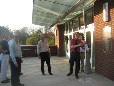
On December 10, 2007, I attended a meeting of the ASCE/EWRI Stormwater M-BMP Maintenance Subcommittee on North Carolina State University campus in Raleigh.

After the meeting, Professor Bill Hunt, the Subcommittee Chair, took us for a field trip to several rainfall/stormwater management sites on campus. One of the photos that I took (shown to the left) was on "rain chains."

"Rain chains do exactly what downspouts do, but they do it in a way that brings visual pleasure and delight. Rain swirls and flows down, creating a mesmerizing sense of motion and tranquility right outside your window." (www.HarvestH2O.com)